IntroductionIn
today’s digital age, the world has become more accessible than ever before, thanks to the power of technology. One of the most remarkable tools that has revolutionized our ability to explore and understand the planet is Google Earth. This innovative application, developed by Google, allows users to embark on virtual journeys to virtually any corner of the globe, offering an unprecedented opportunity to discover and appreciate the beauty and diversity of our planet. In this article, we will delve into the wonders of Google Earth, exploring its features, applications, and impact on our world.
A Window to the World
Google Earth, initially released in 2001 as EarthViewer 3D, has come a long way in providing users with an immersive and comprehensive view of the Earth. At its core, Google Earth is a virtual globe that combines satellite imagery, aerial photography, and geographic information system (GIS) data to create a 3D representation of our planet. Users can zoom in from a global view all the way down to street level, providing an experience that feels like flying over the Earth’s surface.
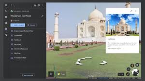
Google Earth image


Key Features and FunctionalitiesSatellite Imagery:
Google Earth’s most iconic feature is its satellite imagery, which covers nearly every part of the world. Users can view the world in stunning detail, from the lush rainforests of the Amazon to the vast deserts of the Sahara.Street View: Google Earth seamlessly integrates with Google Street View, allowing users to explore streets and neighborhoods from ground level. This feature is immensely helpful for travelers, house hunters, or anyone curious about distant places.Historical Imagery: Users can access historical imagery to see how a location has changed over time. This feature is invaluable for studying urban development, environmental changes, and historical events.3D Models: Many major cities around the world are mapped in 3D, offering a lifelike view of buildings, landmarks, and terrain. It’s like having a miniature city at your fingertips.Custom Maps: Google Earth enables users to create custom maps and share them with others. This is handy for planning trips, marking points of interest, or collaborating on geographical projects.
Impact on Society
Google Earth has had a profound impact on society by bridging geographical gaps and fostering a deeper understanding of the world. It has made the world more accessible to everyone, irrespective of physical limitations or financial constraints. This democratization of geographic information has opened up new avenues for education, research, and exploration.
Conclusion
Google Earth is a testament to the incredible capabilities of modern technology. It has transcended its original purpose as a mapping tool to become a gateway to our planet, offering an immersive and educational experience for users around the globe. Whether you’re a student studying geography, a traveler planning your next adventure, or an environmentalist working to protect our planet, Google Earth has something to offer. It has truly changed the way we see and interact with the world, making it an invaluable tool in our digital age. So, the next time you’re curious about a far-flung destination or want to explore your own neighborhood from a different perspective, remember that Google Earth is just a click away, ready to take you on a virtual journey like no other.


